Background
When the Trustees moved Penn to a new campus at 34th Street and Woodland Avenue in West Philadelphia, they were implementing a partnership with the City of Philadelphia which had been nearly a decade in the making. The City’s ownership of the West Philadelphia campus dated to 1829, when the “Guardians for the Relief and Employment of the Poor” purchased 187 acres of “Woodlands,” the Hamilton family estate on the west bank of the Schuylkill River. For sixty years the City had maintained an alms house on Spruce Street, between 10th and 11th Streets, but it had become dangerously overcrowded and the Blockley Township site was both conveniently nearby and many time times more spacious. Over the next few years the City spent nearly $1 million to construct four huge buildings – a men’s housing unit, a women’s housing unit, a hospital, and a “house of employment” — with a total capacity of 4,000 residents. In 1834 all housing and health care operations moved from their city location to the new, rural Philadelphia Almshouse and Hospital, later known as Philadelphia General Hospital.
In 1854, however, the City and County of Philadelphia consolidated into a single governmental unit and almost immediately the number of poor people needing housing and health care overwhelmed the Philadelphia Almshouse facilities. In May 1862, the Commonwealth of Pennsylvania adopted legislation which granted the City the right to sell portions of its 187-acre alms house grounds in order to fund the construction of additional housing and health care facilities for the sick and poor.
Original Purchase: The College Hall Core
On 18 December 1869, by Ordinance of City Councils, the City was authorized to sell 9.962 acres to the Trustees at $8,000 per acre. On 4 January 1870 the Trustees authorized the purchase of the property. [Click to view the 1870 deed and the 1873 mortgage for this property]
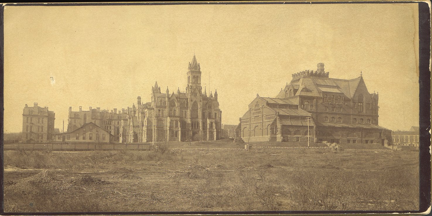
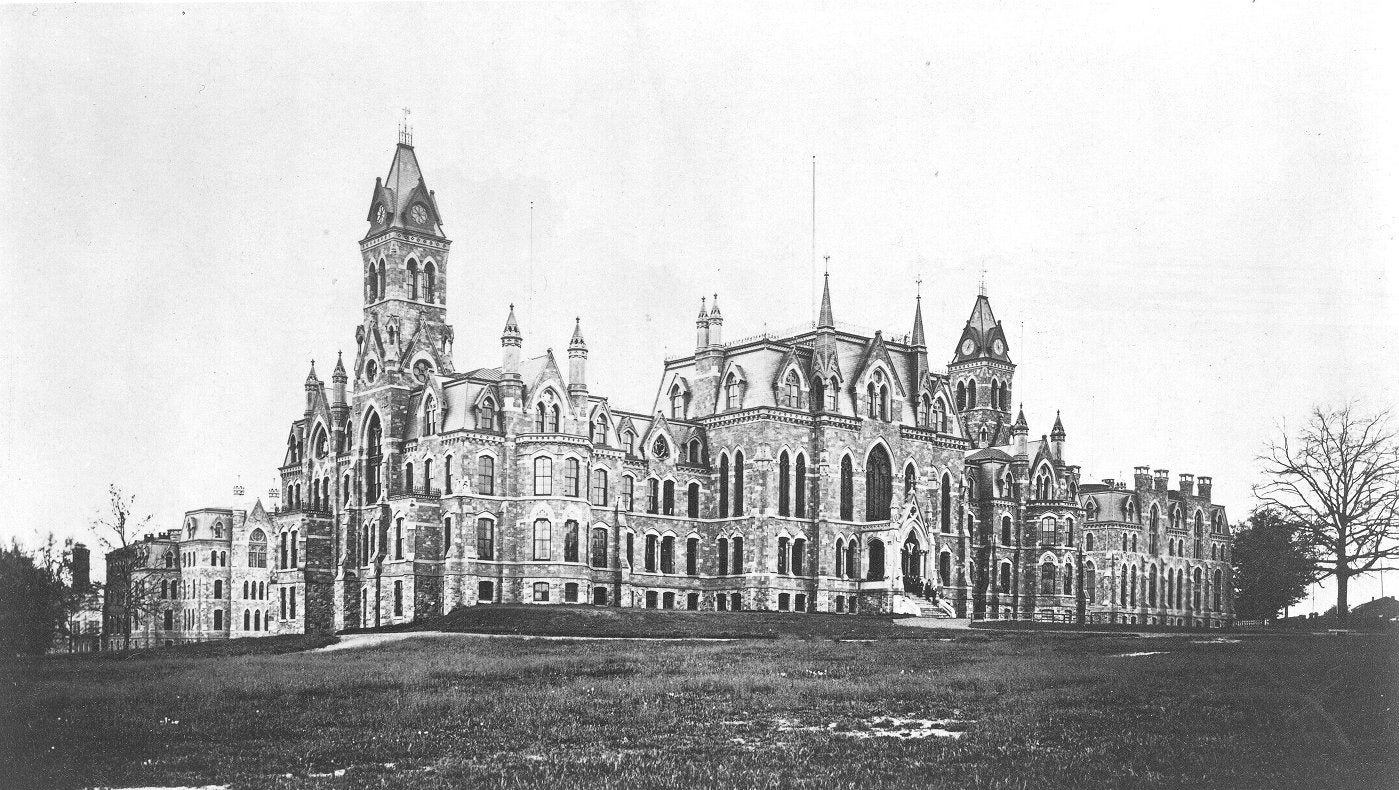
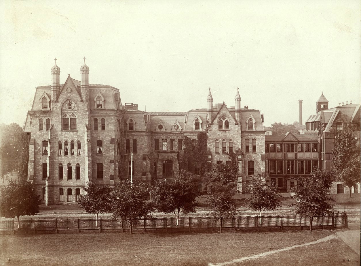
Seven buildings now occupy this land: College Hall, Logan Hall, Williams Hall, Houston Hall, Irvine Auditorium, the Fisher Fine Arts Library, and Meyerson Hall. Two of these – Irvine Auditorium and Williams Hall – replace earlier structures. Irvine Auditorium stands on the site of both the Mechanical Laboratory, built in 1892 and destroyed by fire in 1906 and the Central Light and Heat Plant, built in 1892 and demolished in 1925 to make way for Irvine. Williams Hall stands on the site of the original Medical and Dental Laboratory building, later renamed Hare Hall, which was demolished in 1969. The Trustees also built one other building on the original ten acres which no longer exists: a short-lived Dining Hall, built in 1888 and demolished shortly after the 1896 opening of Houston Hall.
Site for the Hospital of the University of Pennsylvania
On 18 May 1872, by Ordinance of City Councils, the City was authorized to sell 6.892 acres to the Trustees for $500 in cash and 50 free hospital beds for the City’s poor. On 4 June 1872 the Provost presented copies of the Ordinance to the Trustees, who authorized the purchase of the land. On 2 July 1872 the Provost presented the deed to the Trustees. With this purchase, the campus increased in size to 16.854 acres total. [Click to view this 1872 deed]
Thirteen buildings of the Hospital of the University of Pennsylvania now occupy this land: Gates Memorial (1953), Centrex Building (1969), Founders Pavilion (1987), rear of Gibson Wing (1883), Maloney (1929), Rhoads (1995), Donner (1958), Devon MRI Center (1986), Silverstein (1978), Ravdin Institute (1963), Ravdin Courtyard (1973), White Memorial (1922), and Dulles-Agnew (1941).
With the exception of the rear of the Gibson Wing, none of these are original to the site. Gates replaced the Spruce Street fronts of Gibson and the original Central Hospital (1874). The Centrex building replaced the Dispensary. Founders replaced the rear of the Central Hospital. Maloney replaced Pepper Laboratory of Clinical Medicine. Rhoads replaced the Maternity Wing. Donner and Devon stand on the sites of the Isolation Ward, the Mortuary, and the Laundry. Ravdin and Silverstein replaced the Nurses Home.
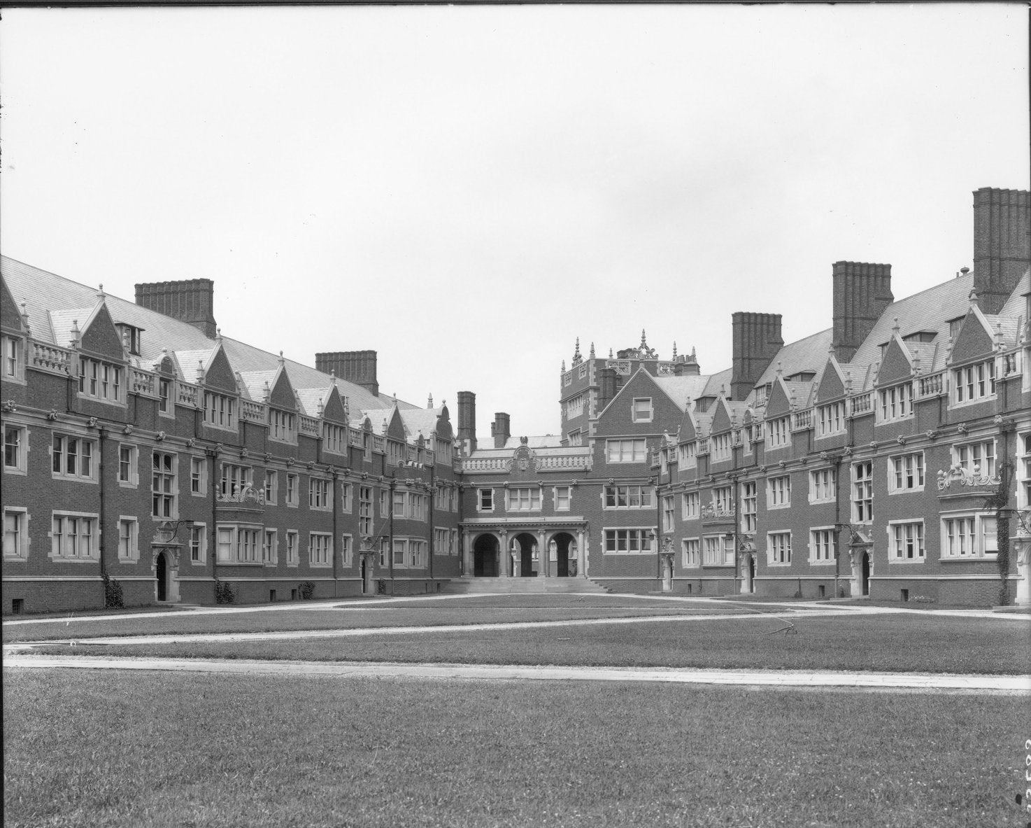
Quads and Medical Labs
On 24 January 1882, by Ordinance of City Councils, the City sold 13.243 acres to the Trustees for $500 in annual cash rent or $10,000 in cash and 50 free scholarships of a total annual value not less than $7,500. With this purchase, the campus nearly doubled in size to 30.097 acres total.
The Dormitory Quadrangles (1895-1954) were the first buildings to be built on this land, During the twentieth century a number of medical labs and scientific buildings have been constructed here: John Morgan Building (1904, with Anatomy-Chemistry Wing of 1928), Leidy Laboratories of Biology (1911, with Kaplan Memorial Wing, 1964), Richards Medical Research Laboratories (1962), Goddard Laboratories (1964, originally known as the Biology Building), Mudd Biological Research Laboratory (1986).
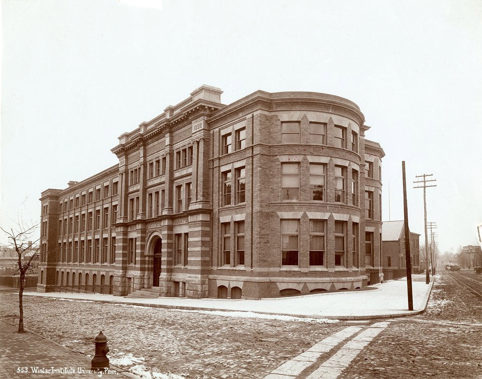
Wistar Institute
On 21 March 1888, by Ordinance of City Councils, the Trustees purchased 0.903 acres of land on the northwest corner of 37th and Spruce Streets from the City sold for $1. With this purchase, the campus increased in size to 31 acres. On 19 March 1892 the University transferred the site to the Wistar Institute. The Wistar Institute is the one building occupying this land.
Land for Pure and Applied Science and for Athletics
On 30 March 1889, by Ordinance of City Councils, the City sold 9.411 acres to the Trustees for $149,800. Five buildings now occupy this land: Vagelos Laboratories (1996), Hayden Hall (1896), Franklin Field (1895, rebuilt in 1922, with upper deck, 1926), Weightman Hall (1904), and the White Training House (1907). The Vagelos Laboratories replaced the Department of Hygiene Building (1892).
This 1889 purchase increased the size of the campus to 40.411 acres total. In 1893 a purchase of adjacent land was again earmarked for science and brought the campus size to 40.797 acres.
On 13 January 1893, by Ordinance of City Councils, the City was authorized to sell 0.386 acres of land at the Northeast corner of 34th and Spruce Streets for $1. At a meeting held on 1 November 1892, the Trustees had authorized the Provost to negotiate for title to the land. At a meeting held on 6 December 1892, the Provost reported progress and the Trustees designated the site for a “Chemical Laboratory” building. One building now occupies this land: Chemistry including the Cret Chemistry Wing (1941), Harrison Laboratory (1958), and the 1973 wing).

Land for "The Purpose of a College for Women"
At the May 1890 meeting of the Trustees “the Provost presented the title deeds of two properties at 34th and Walnut Streets, presented by Col. [Joseph M.] Bennett.” These two townhouses – 3348 and 3350 Walnut Street — stood on the southeast corner of the intersection. The University also acquired from Bennett four, adjacent properties — 3340, 3342, 3344, and 3346 Walnut Street – on or about 1 September 1898 (just four weeks before his death). 3328, 3330, 3332, 3334, 3336, and 3338 Walnut Street purchased between 1 September 1901 and 31 August 1902. On 2 January 1906 the Trustees authorized the Provost to purchase 3316 Walnut Street for $5,200. On 13 April 1914 the Trustees approved the Treasurer’s purchase of 3314, 3320, 3322, and 3324 Walnut Street for $28,250. On 8 June 1914 the Trustees authorized the Treasurer to purchase 3318 and 3326 Walnut Street for $19,500. This completed the University’s ownership of all properties from 3314 Walnut on the east to 3350 on the west. On 12 October 1914 the Trustees authorized the demolition of 3328 to 3350 Walnut Street.
With the establishment of the Graduate Department of Women in 1891, the two houses at 3348 and 3350 Walnut Street became known as “Bennett Hall” and served as Penn’s first women’s student center and residence hall. In 1914 “Bennett Hall” relocated to the two houses at 3324 and 3326 Walnut. After the demolition of the twelve houses at 3328 to 3350, the corner lot stood vacant for nearly a decade. During the latter half of this period it was known as the “University Playground” and operated by the Playgrounds Association of Philadelphia. A third Bennett Hall (1925) now occupies 3328 to 3350 Walnut Street. In October 1931 the City of Philadelphia condemned the two houses at 3324 and 3326 Walnut Street and they were demolished. Acquisition of the house at 3312 Walnut Street and demolition of the six houses at 3312 to 3322 Walnut Street occurred on unknown dates. The Graduate Research Wing of the Moore School now occupies 3312 to 3326 Walnut Street.

Land for the University Museum
On 30 March 1894, by Ordinance of City Councils, the City granted to the University, in trust, “8 acres, more or less” at the southeast corner of 34th and Spruce Streets for “a museum and botanical garden and park … and also to erect thereon a Museum of Science and Art.” At a meeting held on 1 November 1892, the Trustees had authorized the Provost to negotiate for “occupancy of the 70 acres of land to the south of South St. now dedicated to Park purposes.” On 3 April 1894 the Trustees voted to place the land “under the direction of the Department of Archaeology and Paleontology with authority to lay out the same as a free Museum and botanical garden and park.” On 29 October 1895, by Ordinance of City Councils, the City deeded to the University, in trust, a second tract of land at the southeast corner of 34th and Spruce Streets “upon the same terms as the former grant.” On 5 November 1895 the Trustees authorized the Provost to “accept the conveyance in trust for public use as a Museum, botanical Garden and Park.” This piece of ground measured approximately 1.286 acres. The first two buildings of the University Museum complex now occupy this site.
Thus by 1895, the University’s West Philadelphia campus had expanded to 48.797 acres (reported in the 1895 Catalogue as 47.5 acres).

Sources
Text Sources
- Background: For additional historical information, see John Welsh Croskey, M.D., History of Blockley: A History of the Philadelphia General Hospital (Philadelphia: 1929) and John L. Cotter, et al, The Buried Past: An Archaeological History of Philadelphia (Philadelphia: 1992).
- College Hall area: Minutes of the Trustees of the University of Pennsylvania (hereafter referred to as Trustees Minutes) 11: 33 (4 January 1870). In order to complete this area, during the next few years the Committee on Ways and Means was authorized to purchase the triangle “bounded by Woodland St., 34th St. and Locust St.” and also the triangular lot at 34th Walnut and Darby Road. See the Trustees Minutes 11: 109 (7 January 1871) and 11: 214 (5 August 1873)
- Hospital of the University of Pennsylvania: Trustees Minutes 11: 150 (4 June 1872) and 11: 158 (2 July 1872).
- Quads and Medical Labs: Trustees Minutes 11: 609 (6 December 1881) and 11: 614-16 (28 January 1882).
- Wistar Institute: Trustees Minutes 12: 366 (7 February 1888) and 12: 374 (3 April 1888).
- Athletics and Science: Trustees Minutes 12: 449 (5 March 1889) and 12: 458 (2 April 1889). Trustees Minutes 13: 55 (1 November 1892) and 13: 66 (6 December 1892).
- College for Women: Trustees Minutes 12: 536 (6 May 1890), 14: 416 (2 January 1906), 16: 107 (13 April 1914), 130 (8 June 1914), and 146 (12 October 1914). See also, Annual Report of the Provost to the Board of Trustees, 1897-1898, p. 219 and Annual Report of the Provost to the Board of Trustees, 1901-1902, p. 189. Bennett News, 15 October 1931 (8: 2), p. 1.
- University Museum: 1896-97 Catalogue, p. 307; Trustees Minutes 13: 55 (1 November 1892), 13: 170 (3 April 1894), and 13: 320 (5 November 1895).
Land Records Available Online
- University Real Estate Documents (Deeds)
- Mapping Penn: Land Acquisitions, 1870-present
- Campus Growth, 1870-2015
- Also see:
Photographs
- All photographs are from the folder: “Campus General/ 19th Century Views, Misc.,” University Archives Photograph Collection
Maps
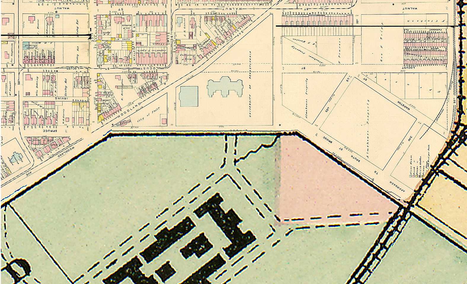
- 1878 Map was compiled from the “Atlas of the 24th, & 27th Wards, West Philadelphia, From Official Records, and Actual Surveys, Based upon Plans Deposited in the Department of Surveys” surveyed and published under the direction of J.D. Scott, Philadelphia, 1878. part of the “Index Map of West Philadelphia,” Plate A, p. 3
- City of Philadelphia, Almshouse Property, 27th Ward, 1882; Dec. 20, 1882 (mss notation at the bottom; “Areas calculated May 1889 Samuel Smedley, Chief Bureau of Surveys”)
- “University of Pennsylvania Location of Buildings” included at the back of: Acts of Legislature and Ordinances of City Councils respecting Blockley Farm. 1861-’94. (Reprinted from the Report of Provost Pepper, June, 1894. Philadelphia: Avil Printing Company, 1894)